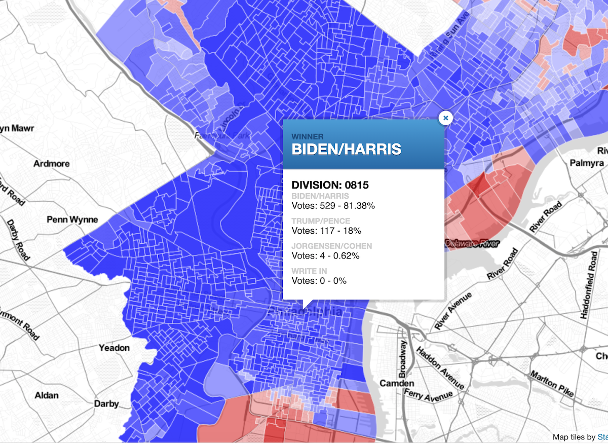
We’re solidly in day three of counting votes for the general election that took place Tuesday, and as Joe Biden takes a lead in Pennsylvania, we can take a look at which neighborhoods the former vice president is winning handedly in majority-Democrat Philadelphia.
Wes Weaver, a senior GIS and data analyst at the Philly District Attorney’s Office tweeted out a side project he’d produced in the days after the election: a ward-by-ward map looking at votes for Biden or President Donald Trump. Unsurprisingly, a majority of the city is deep blue, with places like North and West Philly reporting very high numbers for Biden, while pockets of Port Richmond, South Philly and the Northeast leaned toward Trump.
I made a map. Philly 2020 presidential general election (preliminary) results by division. https://t.co/fw82990jl4
— Wes Weaver (@WesWeaver) November 6, 2020
If you know your ward number (of if you scroll in far enough on the map to see your block) you can see total updated voters; numbers that voted for Biden, Trump and third-party candidate Jo Jorgensen; and if there were any write-in votes for your neighborhood. The ward that encompasses City Hall, for example, has logged 529 votes (81.4%) for the Biden ticket, 117 votes (18%) for the president’s ticket and four votes (.6%) for Jorgensen.
Like The Temple News Digital Managing Editor Colin Evans, who made an interactive map to see voter turnout data for every neighborhood, Weaver wrote a script in R to pull the division shape data from OpenDataPhilly to join the vote counts to each division, and create the map. It uses the turnout data, which the City Commissioners Office provides, as well as a later release of data which shows how people voted.
It’s one of many data-focused side projects the GIS pro produces, and he’s done some work on elections in the past. He usually creates election maps because they’re fairly easy to make, he told Technical.ly, and because it’s hard to find this division-level results in news updates.
“I got into this field because I’m an activist first, and strongly believe in using data to inform public policy and promote transparency in government,” Weaver said. “That’s why I’m at the DA’s office now. The staff at the City Commissioners Office have done a great job — better than anyone else in the state — at making this data open to the public.
His intention is translate the onslaught of data the city releases into an accessible and usable map for the public so folks can better understand what’s happening in their neighborhoods and throughout the city. He’s especially interested in elections that are close or contentious, he said — both of which this election is turning out to be.
“And I often talk to people who are surprised to learn that dozens of people in their immediate neighborhood voted differently than they’d expect,” Weaver said. “I just heard from someone who was stunned that about a third of their neighbors voted for Trump, for example.”
Weaver’s also shared links to some maps that dive into how Philadelphians voted on the different ballot questions, such as “Should Philadelphia borrow $134 million for capital purposes?” Results show it was supported in the same areas Biden is picking up most of the votes and not supported in Trump neighborhoods.
Ballot question 4: Should Philadelphia borrow $134 million for capital purposes. It's not boring, you're boring. https://t.co/EjyrACgyaX
— Wes Weaver (@WesWeaver) November 6, 2020
More of Weavers’ data projects can be found on his website.
Before you go...
Please consider supporting Technical.ly to keep our independent journalism strong. Unlike most business-focused media outlets, we don’t have a paywall. Instead, we count on your personal and organizational support.
Join our growing Slack community
Join 5,000 tech professionals and entrepreneurs in our community Slack today!

I’m a teenager who quit social media — and I’ve never been happier

Supreme Court upholds TikTok ban, as creators and communities brace for impact

Four ways Trump could upend the tech world in his first 100 days


