Philip Silva and his cofounder Liz Barry created TreeKIT because “of a realization that as the city has been planting one million trees, it is pretty much relying on volunteers to take care of those trees.”
Which is fine, but there’s a coordination problem, Silva said.
If three volunteers have an hour to spend one weekend watering, pruning or mulching trees, how can they make sure that they don’t provide stewardship to a tree that another volunteer worked on the day before when another tree around the corner could really use some attention?
TreeKIT is building an map-based platform to make that possible. Right now, they are working first on getting all the trees onto a map. Then they will work with Open Tree Map, an open source platform from a Philadelphia company called Azavea, to load all those trees and give them access to online tools for tracking stewardship.
See the TreeKIT map
The TreeKIT map, showing blocks in Gowanus and Prospect Heights.
The first neighborhood the team mapped was Prospect Heights, with funding from the NYC Parks Department. That’s where Silva was living at the time (he’s in Ithaca right now, but his cofounder has remained in Williamsburg). They also found that Prospect Heights had a surprisingly diverse forest of trees, both in terms of species and maturity.
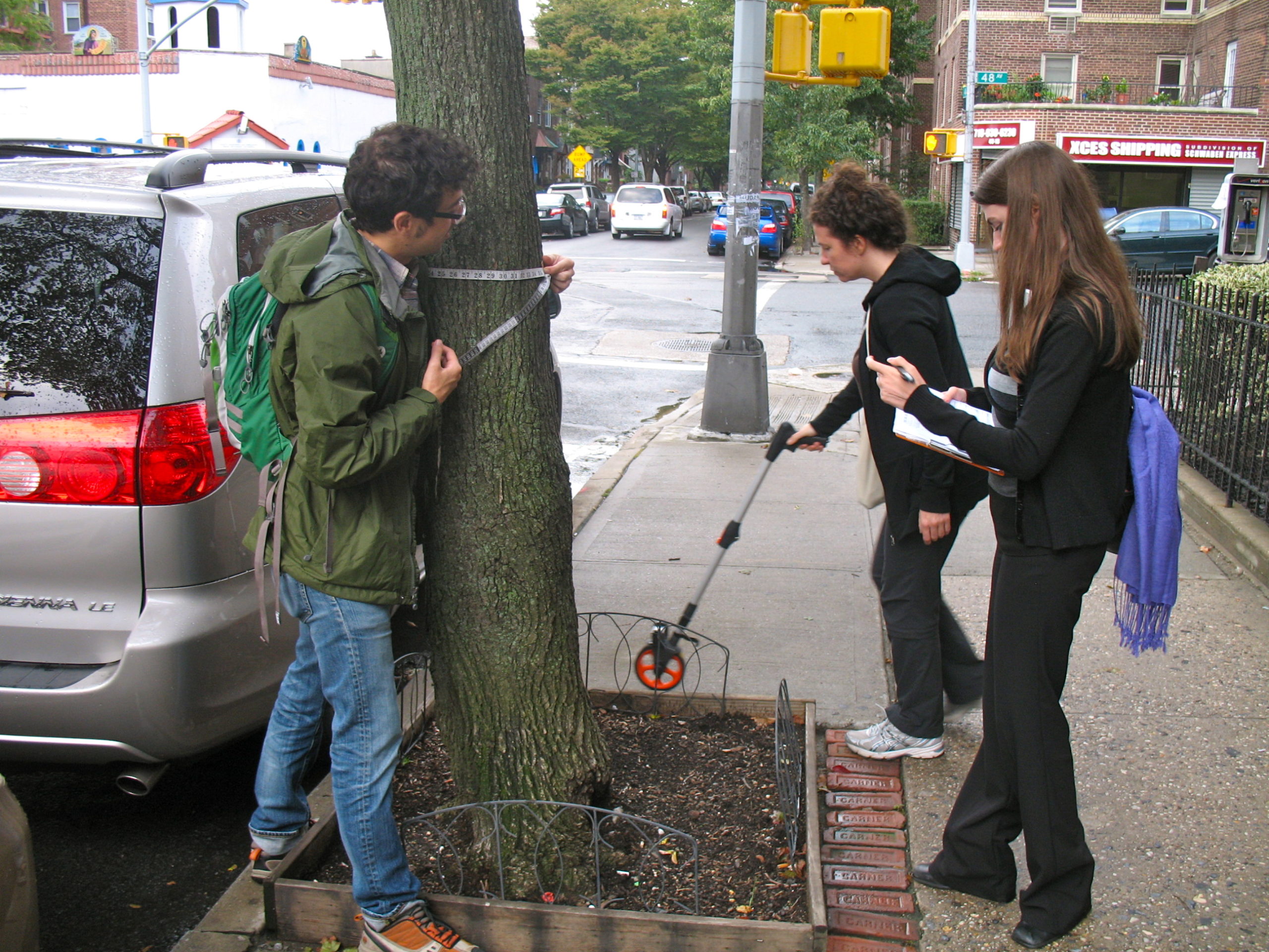
Right now, TreeKIT volunteers map trees using an $80 kit that looks much like what engineers or surveyors carry, logging location data of trees and tree beds on sheets of paper, which volunteers then enter into a webform that ultimately feeds them into a script written by a cartographer that puts them onto the TreeKIT map.
The group is working with OpenPlans and CartoDB to create a smartphone interface that will allow volunteers to enter measurements on their screens, then verify them by looking at how the database interpreted their entries right on their smartphone screens, making corrections as needed.
Even once the system goes onto smartphones, the team plans to keep making its measurements using analog tools. Silva explained that GPS mapping in New York just isn’t accurate enough for tracking trees at this point, and volunteers would still need to use tape and rulers to note the size and shape of the tree bed and tree girth.
Silva told Technical.ly Brooklyn that TreeKIT and its partners at the Parks Department believe that the entire city forest needs to get mapped first before rolling out stewardship tracking. That seems like a heavy lift, but Silva explained the group hopes to find a neighborhood partner in every part of the city to undertake their part of the work.
For example, the Gowanus Canal Conservancy has helped the team to map 70 blocks in their neighborhood. Gowanus neighbors, of course, have a very strong incentive to keep stormwater under control. TreeKIT is also in talks with the Parks Department to make its 2015 Tree Census the first spatial census.
Of the 12,000 trees that the team has mapped so far, about 2,100 of them are in Brooklyn.
Silva said there are benefits to the city’s environment by employing volunteers to use analog methods to track trees. “The process invites a long leisurely walk through the urban forest,” he said, explaining that by empowering people to begin identifying the trees around them and their stewardship needs, they turn casual volunteers into forestry advocates.
Here are some photos of TreeKIT volunteers in action around the city, supplied by TreeKIT:


Before you go...
Please consider supporting Technical.ly to keep our independent journalism strong. Unlike most business-focused media outlets, we don’t have a paywall. Instead, we count on your personal and organizational support.
3 ways to support our work:- Contribute to the Journalism Fund. Charitable giving ensures our information remains free and accessible for residents to discover workforce programs and entrepreneurship pathways. This includes philanthropic grants and individual tax-deductible donations from readers like you.
- Use our Preferred Partners. Our directory of vetted providers offers high-quality recommendations for services our readers need, and each referral supports our journalism.
- Use our services. If you need entrepreneurs and tech leaders to buy your services, are seeking technologists to hire or want more professionals to know about your ecosystem, Technical.ly has the biggest and most engaged audience in the mid-Atlantic. We help companies tell their stories and answer big questions to meet and serve our community.

Join our growing Slack community
Join 5,000 tech professionals and entrepreneurs in our community Slack today!