
Aerial Applications is using more than 20 drones to soar over parts of North Carolina affected by Hurricane Florence, in an effort to gain images to aid in recovery missions.
The team is set up and working out of an emergency operations center (EOC) for undisclosed private-sector clients in Wilmington, N.C.
Aerial Applications CEO Joe Sullivan is currently on the ground there. Aerial Application was previously headquartered in Philly but has since moved HQ to 1776 DC. The company recently received an honorable mention in the Social Good category from Fast Company’s “Innovation by Design” awards.
Aerial Applications collects and processes data from drones, and builds software that makes using that data easy for businesses. This is the company’s third straight year aiding with emergency management. With a team of more than 20 drone pilots, Aerial Applications is helping improve telecommunication recovery efforts by providing drone data on locations that ground crews have limited or no access to.
The company declined to name the clients it is working with but said there are several.
“We are proud to be able to do our part to aid in recovery efforts,” Sullivan said in a statement. “In the past, our data and software have helped clients respond twice as fast to repair outages. Florence is a particularly tough operating environment, but every minute we can save our clients is important to the communities they support.”

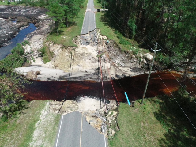
An Aerial Applications drone image of Hurricane Florence damage in North Carolina. (Courtesy photo)
The team began mobilizing about a week ahead of the storm, and its first flight operations began on Sunday. For one of its clients, Aerial Applications is flying drones over telephone lines to take pictures that are then overlaid on maps. The technology makes it easier to identify the extent of the damages.
Aerial Applications is coordinating with the Federal Aviation Administration (FAA) in all its missions, according to Sullivan. Around the clock image-processing teams have been working through the night while pilots fly and collect data during the day, the company says.
After operations conclude in North Carolina, the company says it will shift missions for another client, likely in South Carolina.
Join the conversation!
Find news, events, jobs and people who share your interests on Technical.ly's open community Slack

'Be bold': This digital innovation and business strategist urges fellow women leaders to be their authentic selves

New DMV conference aims to connect women innovators and developers

What US entrepreneurs can learn from a Chinese policy wonk: Build with your values in mind
