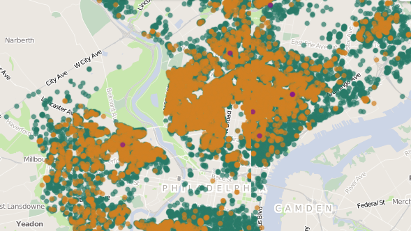
Visualize more than 32,000 of the city’s vacant lots with a new mapping tool.
Called Grounded in Philly, the map offers information on each vacant lot, like square footage, the name of its owners and different ways to gain ownership of the lot. It also allows users to add information about lots, like if it’s a community garden or being used for another purpose, and to connect with other neighbors who are concerned about a certain lot.
Visit Grounded in Philly here.
It’s the first time all this data, from multiple city government sources, has been accessible in one place. (PlanPhilly created a map of the city’s vacant lots in 2011 but that version does not have as much data as Grounded in Philly.)
The map is a project of the Garden Justice Legal Initiative at the Public Interest Law Center of Philadelphia and 596 Acres, a Brooklyn-based vacant lot education program that launched a similar tool in Brooklyn. The site was designed by local designer Jason Killinger.
Experts say that Philadelphia has more than 40,000 lots, so this map isn’t an exhaustive source. There currently isn’t a way for people to add vacant lots on their own (the team is working on that), but people can contact Grounded in Philly to get those lots on the map.
Other vacant land tech initiatives include: PhillyLandBank.org and Possible City‘s vacant lot map, which only maps publicly-owned vacants.
Join the conversation!
Find news, events, jobs and people who share your interests on Technical.ly's open community Slack

Philly daily roundup: Technical.ly's new editor; Meet Diversitech's founder; Flaws in planned TikTok ban

Edtech CEO looks back on the promises of summer 2020: 'It never rang true to me'

Technical.ly boosts editorial team with hire of experienced tech journalist