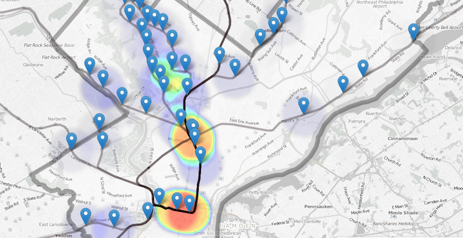
Trace more than five years of violent crime near SEPTA Regional Rail stops with this heatmap from developer (and Technical.ly contributing web editor) Jim Smiley. It uses the crime API the city released last year.
Smiley hopes to do the same for every bus and rail route in the city, he tells us.
The map doesn’t account for population density or other variables that impact how the map displays, but it does give a sense of how some might see their transit experience. Smiley pointed out this lack of context in a follow-up blog post about the map, where he wrote “my Regional Rail stop crime heat map sucks at telling a story” and pointed out how that can actually be harmful.
In related news, the Daily News reported that SEPTA police are cracking down on quality-of-life crimes (like loitering, fare evasion and disorderly conduct) at Olney Transportation Hub as a crime prevention measure.
Join the conversation!
Find news, events, jobs and people who share your interests on Technical.ly's open community Slack

Philly daily roundup: Student-made college cost app; Central High is robotics world champ; Internet subsidy expiration looms

Philly daily roundup: Earth Day glossary; Gen AI's energy cost; Biotech incubator in Horsham

Philly daily roundup: Women's health startup wins pitch; $204M for internet access; 'GamingWalls' for sports venues